|
The Bayou District Foundation's Proposed Land Grab
|
|
2/28/2009
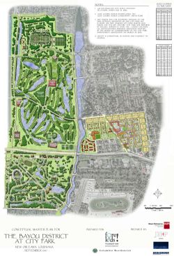
While the loss of public park land in City Park's version of the revised 2007 Master Plan is disturbing, it pales in comparison to the Bayou District Foundation's "Conceptual Master Plan" for City Park, which is downright chilling. Basically, the entirety of City Park north of I-610 would become an extension of their new housing development across the bayou. The North Course would cease to exist, its land used for the BDF's new softball and soccer complexes, the Police Stables are no more, and the Couturie Forest is shrunken and surrounded by golf courses.
How inconvenient that so many critics, lowly New Orleans residents all, have interfered with their plans to take over all of this "underutilized" public property for their private development concerns.
From their "Highlights of the Bayou District of New Orleans", they claim their plan is to:
-Redevelop approximately 1,300 acres of New Orleans City Park, the country's second-largest urban park;
-Plans include two 18-hole championship golf courses, a nine-hole executive golf course, a First Tee Learning Facility and eight baseball, softball and soccer fields;
-Golf facility will be affordable to New Orleans residents and tourists;
-The revitalized course will be the home of the PGA Tour supported First Tee of New orleans and will be capable of hosting local, regional and national golf and other sports events;
-A portion of the proceeds from the golf operations will be available to support the vocational, pre-school, after school and other programs within the new Bayou District residential community, an estimated $1,500,000 annually;
-The Fore!Kids Foundation will manage the golf operations and New Orleans City Park will manage the recreation.
  BDF's Conceptual Master Plan for City Park BDF's Conceptual Master Plan for City Park
Attachment:
Highlights of Bayou District Foundation's plan for City park
|
|
|
Comments (0)
|
|
|

|
|
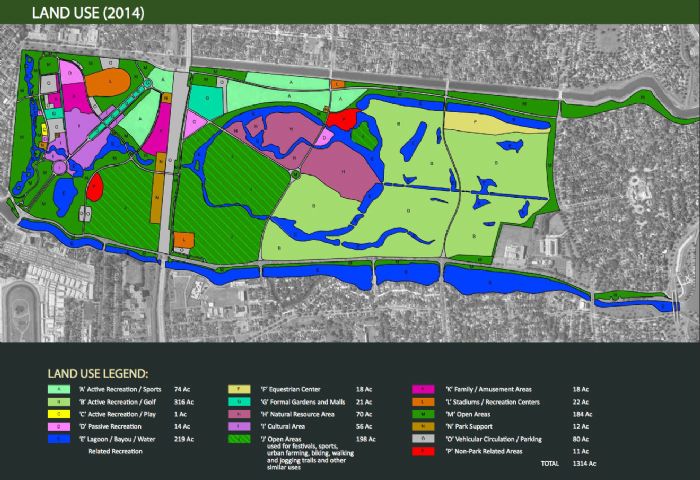
2014 Revised Land Use Plan Showing Downsized Master Plan for Golf and NOT showing the planned destruction of 5.5 acres of Couturie Forest.
|
|
3/28/2015
As per the revised 2014 City Park Master Plan. Note the borders of the Couturie Forest's "natural resource area" continue to remain intact in relation to the golf course footprint, although we NOW know that City Park planned to bulldoze 5.5 acres of the Couturie Forest to be added to the new golf course.
|
|
|
Comments (0)
|
|
|
|
|
|
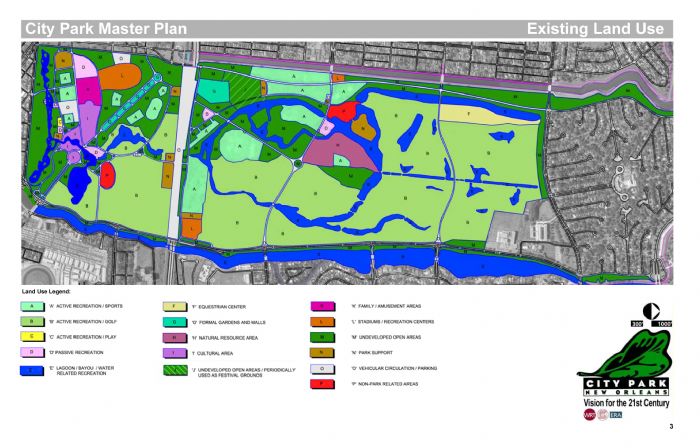
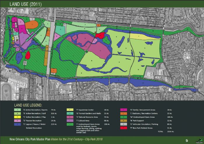
2005 Existing City Park Land Use in 2005 (from 2005 and 2007 Master Plans)
|
|
Existing land use as designated by City Park management
2/28/2009
In these land use maps from the 2005 City Park Master Plan and the revised version from 2007, the deep green areas labeled "M" represent "undeveloped open areas", which includes the grassy strips along roads as well as limited public access areas such as Scout Island; the purple areas labeled "H" represent "natural resource areas" such as Couturie Forest; and the light lime green areas labeled "B" are for golf. It is evident in this map that golf consumed more than 50% of the land in the park previous to 2005, when the south course was closed to make way for a fenced "festival" area whose public access has not been made clear. Despite the distinction between the purple and green areas of Couturie Forest, there is no physical or visual difference between these areas.
|
|
|
Comments (0)
|
|
|
|
|
|
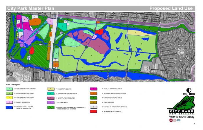
Proposed Land Use Changes in the 2005 Master Plan
|
|
2/28/2009
Under the 2005 Master Plan, there appeared to be some tiny gains in the purple "natural resource areas" ("H") and the green "undeveloped open areas" ("M"), but the striped green "festival" area remains a wild card since it isn't clear whether the public will have access to it as open green space when it's not being used for revenue-producing events. The light lime green golf areas ("B") had shrunk to approximately 42% of the park. Note the borders of the Couturie Forest's "natural resource area" remain intact in relation to the old golf course footprint.
|
|
|
Comments (0)
|
|
|
|
|
|
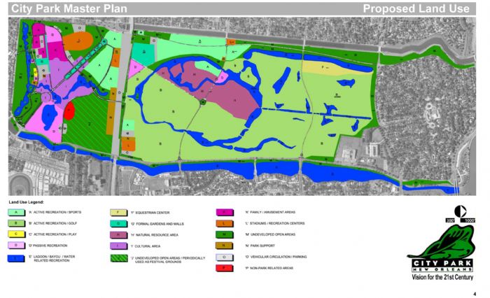
Proposed Land Use Changes in the revised 2007 Master Plan
|
|
2/28/2009
Unfortunately, open green space and natural resource areas have clearly suffered a setback in this new version of the land use map, as compared to both the existing use and the original planned use from the 2005 Master Plan, shown above. The Softball Complex and police stables have vanished, devoured by the proposed new golf courses, which are back to consuming approximately 48% of the space in City Park. On the south side of I-610 (to the right in these maps), additional development has further reduced the amount of passive open green space available to park users.
The new course supporters are fond of using the number "400 acres" to describe the amount of land the new courses will occupy in the park. Keeping in mind that the entire park is said to be 1300 acres, then using simple math, 400 acres would occupy less than a third of the park.
It didn't take a rocket scientist to look at the map and see that the "400 acres" figure was wrong, and the CPIA finally admitted that they were only counting land mass and not water acreage. Which begs the question: why did they keep using that disingenuous number, and what else are they trying to hide?
However, please take note that the borders of the Couturie Forest's "natural resource area" continue to remain intact in relation to the old golf course footprint.
|
|
|
Comments (0)
|
|
|
|
|
|
2011 Revised Land Use Plan Showing Downsized Master Plan for Golf
|
|
1/5/2013
As per the revised 2011 City Park Master Plan. Note the borders of the Couturie Forest's "natural resource area" continue to remain intact in relation to the golf course footprint.
|
|
|
Comments (0)
|
|
|
|
|
|
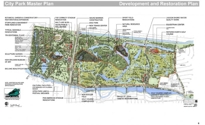
2007/2009 Development Plan showing Golf Course Expansion and Children's Museum sites
|
|
This plan details the increase in development proposed in 2007 versus the 2005 Master Plan
2/28/2009
This "Development and Restoration Plan" from the revised 2007 City Park Master Plan details the major differences from the same rendering in the 2005 Master Plan. In addition to the loss of the softball complex, park land that was supposed to become open green space or be left as undeveloped natural areas in the 2005 plan is sacrificed for development, primarily for the expansion of the proposed new $46 million golf complex. No matter how many times the developers claim the area for golf is not expanding, the maps tell a different story entirely. Note the borders of the Couturie Forest's "natural resource area" continue to remain intact in relation to both the old and new golf course footprint.
|
|
|
Comments (0)
|
|
|
|
|
|
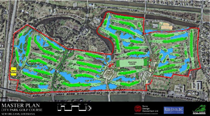
2009 City Park Golf Master Plan rendering, for the new $46 million golf complex
|
|
Prepared by Torre Design Consortium, Ltd and Rees Jones, Inc
2/28/2009
This is the plan of the new $46 million golf complex in City Park, prepared for New Orleans City Park Improvement Association and the Office of Facility Planning & Control of the State of Louisiana, submitted February 2009 by Torre Design Consortium, Ltd and Rees Jones, Inc golf course designers. It depicts two 18-hole golf courses separated by the clubhouse, which has been moved closer to the center of the park so the noise from private parties doesn't disturb the nearby residents along Bayou St John, plus a 9-hole short course adjacent to the "Golf Learning Center".
|
|
|
Comments (0)
|
|
|
|
|
|
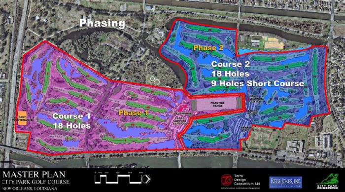
City Park Golf Course Construction Phasing (2009)
|
|
2/28/2009
While the project has been downsized to include only Phase 1, no information about changes to the design has been released.
|
|
|
Comments (0)
|
|
|
|
|
|
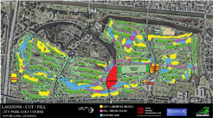
New lagoon plan for the proposed $46 million Golf Complex (2009)
|
|
2/28/2009
In order to build 2 new golf courses, the new golf plan seems to require not only the land area previously occupied by 3 golf courses, but some extra land as well. One of the reasons may very well be the intention of digging many, many more lagoons than are currently present. More water, less land. Very costly. But maybe when they talk about the mysterious "400 acres" that the new courses supposedly occupy, they're not counting the water areas to come up with that low number?
|
|
|
Comments (0)
|
|
|
|
|
|
CPIA BDF Managment Agreement for Golf Complex
|
presented to the Board November 27, 2012
cityparknola
2/19/2013
Chief Executive Officer Becker indicated that the Management Report outlined this process in further detail (a copy of which is attached), but the basic terms of the CEA included a term of 35 years, a contribution of Eight Million Nine Hundred Thousand ($8,900,000) of capital (including in-kind goods and services) by the BDF, an allocation of the Net Operating Income ("NOI") of 75% to NOCPIA and 25% to the BDF of the first $1,150,000 of NOI with any amount of NOI received in excess of that amount be allocated 55% to CPIA and 45% to the BDF.
Commissioner Tom Fierke asked about the return of contribution of the Management Fee, and Chief Executive Officer Becker indicated that the operator will be paid a Management Fee equal to four percent (4%) of Gross Revenues earned each fiscal year for the operation of the Golf Complex, which is similar to the arrangement NOCPIA currently has with Billy Casper Golf. As set forth by the BDF response to the RFP and as stated in the CEA, the operator will contribute seventy-five percent (75%) of its Management Fee (or three percent (3%) of Gross Revenues) for capital improvements in the Golf Complex.
Commissioner Gerry Schoen asked Mr. Gerry Barousse, a representative of the BDF who had previously made a public comment, what the schedule will be for the implementation of the new golf course. Mr. Barousse indicated that depending on when the State released the plans for bidding, the new golf course would open in either 2014 or 2015.
CPIA BDF Managment Agreement for Golf Complex
|
|
|
Comments (0)
|
|
|
|
|
|
RFP request notice from CPIA
|
|
1/12/2010
The New Orleans City Park Improvement Association is issuing a Request for Proposals (RFP) to identify parties who are interested in Contributing Capital and/or Services and Participating in the Development, Operation and Management of the golf complex at City Park in New Orleans, Louisiana.
Parties interested in receiving the RFP packet may request the packet in writing from the New Orleans City park Improvement Association, 1 Palm Drive, New Orleans. Louisiana 70124, ATTN: Robert W. Becker, CEO. The packet may also be picked up at the temporary offices of City Park Improvement Association, on Victory Drive in City Park. Proposals must be received no later than 2:00p.m. Thursday, February 11th, 2010. A pre-proposal meeting will be held at the Pavilion of the Two Sisters at New Orleans City Park on 12 Victory Drive in New Orleans, Louisiana on Thursday January 14, 2010 at 10:00 a.m. All inquiries regarding the RFP should be submitted in writing to Robert W. Becker (bbecker@nocp.org).
Other details include: no compensation during fiscal years 2009 and 2010; Contractor may receive an agreed upon portion of the management fee from the operation and management of the North Course and Driving Range after the expiration of the current BCG management contract but prior to the completion of the Phase I Project, which is expected to be operational and generating revenue by the summer of 2012; the contract will terminate on December 31, 2035 (thus a term of roughly 25 years).
Pages 1-16 of City Park Golf Request for Proposals, outlining some of the details.
|
|
|
Comments (0)
|
|
|
|
|
|
The City Park Golf �400 acres� Puzzle
|
|
3/14/2009
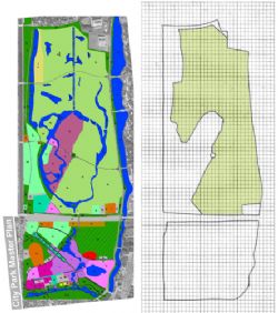
City Park is reported to be 1300 acres total. The new golf course planners claim the courses will be taking up �only 400 acres� of the park, or 31%. Since the only way these experts could come up with this low number is to not count the water features, we have created this handy grid map so everyone can attempt to determine for themselves what the real percentage of City Park area used for golf will be if these plans are approved. Have fun!
Directions: Download the pdf below and print it out. Count all the squares within the outer park boundary to get a total, then add up all the squares in green, representing the new expanded golf courses. Multiply the number of green squares by 100 and divide that number by the total number of squares, which will give you the percentage of the total being used for golf. Then multiply by 1300 acres, and voila! you have the number of acres planned for golf. Hint: we came up with 45%-47%, or roughly 600 acres.
400AcresPuzzle.pdf
|
|
|
Comments (0)
|
|
|
|
|
|
|
)
)
)
)
)
)
)
)
)
)
)